
دورية أكاديمية
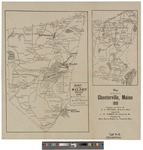
Map of the Town of Chesterville, Maine in 1910
| العنوان: | Map of the Town of Chesterville, Maine in 1910 |
|---|---|
| المؤلفون: | Mitchell, Harry Edward, Robbins, C. W. |
| المصدر: | Map Collections at the Maine Cultural Building |
| بيانات النشر: | Digital Maine |
| سنة النشر: | 1910 |
| المجموعة: | Maine State Documents (Maine State Library) |
| مصطلحات موضوعية: | Maine, Wilton, Chesterville, Maps |
| الوصف: | A pamphlet with sketch maps of Wilton and Chesterfield Maine listing residents. ; https://digitalmaine.com/maps/1115/thumbnail.jpgTest |
| نوع الوثيقة: | text |
| وصف الملف: | image/tiff |
| اللغة: | English |
| العلاقة: | https://digitalmaine.com/maps/116Test; https://digitalmaine.com/context/maps/article/1115/type/native/viewcontentTest |
| الإتاحة: | https://digitalmaine.com/maps/116Test https://digitalmaine.com/context/maps/article/1115/type/native/viewcontentTest |
| رقم الانضمام: | edsbas.11904977 |
| قاعدة البيانات: | BASE |
| الوصف غير متاح. |